
India is set to experience a widespread spell of rainfall and thunderstorms through the end of this week as two significant weather systems continue to influence the country’s atmospheric conditions. As per the latest bulletin released by India Meteorological Department (IMD), heavy to very heavy rainfall, thunderstorms, and gusty winds are expected across multiple regions from October 30 to November 2. The weather condition is triggered by the combined impact of the remnant system of Severe Cyclonic Storm Montha and a depression over the east central Arabian Sea.
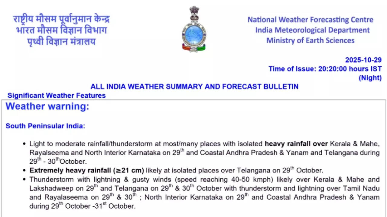
As per the bulletin, in the southern peninsula, light to moderate rain and thunderstorms will occur over most areas, with isolated heavy rainfall particularly likely along coastal Andhra Pradesh, Telangana, eastern Madhya Pradesh, Vidarbha region, and Chhattisgarh on October 30. Telangana is set to experience thunderstorms with lightning and gusty winds reaching up to 50 kmph (the after effects of Cyclone Montha), while chances of thunderstorms accompanied by lightning are there for Tamil Nadu, Puducherry, Karaikal, and Rayalaseema during the same period.The eastern coast’s weather conditions will remain unsettled with squally winds and rough seas over the Andhra Pradesh and south Odisha coasts. This is expected to extend into the east central Arabian Sea. Wind speeds could reach 55 kmph. Fishermen are advised to avoid venturing into the sea. Similar conditions are expected along the Karnataka, Konkan, and Goa coasts.
Heavy to very heavy rainfall in east, west and central India
In eastern and central India, rainfall is expected to intensify as the deep depression over south Chhattisgarh continues its northward journey. The weather system will continue to cause heavy to very heavy rain across Bihar, Jharkhand, Chhattisgarh, and West Bengal over the next few days. On October 30, Bihar and parts of eastern Madhya Pradesh are expected to witness very heavy downpours, followed by similar conditions in sub-Himalayan West Bengal and Sikkim on November 1.Between October 30 and November 1, light to moderate rain and isolated heavy to very heavy rainfall is expected in Gujarat, Saurashtra region, and Kutch region. The IMD forecasts thunderstorms with lightning to continue across the entire Gujarat region for the next several days, with wind speeds reaching up to 65 kmph along the coast. Rough sea conditions off north and south Gujarat are expected, combined with gusty winds over the northeast Arabian Sea. By October 31, Saurashtra and Kutch are expected to be among the worst-affected areas, receiving very heavy rainfall. Rainfall will extend inland to the Gujarat region, and thunderstorms accompanied by lightning and strong winds will remain a persistent feature until at least November 2.
Alert for northeast India
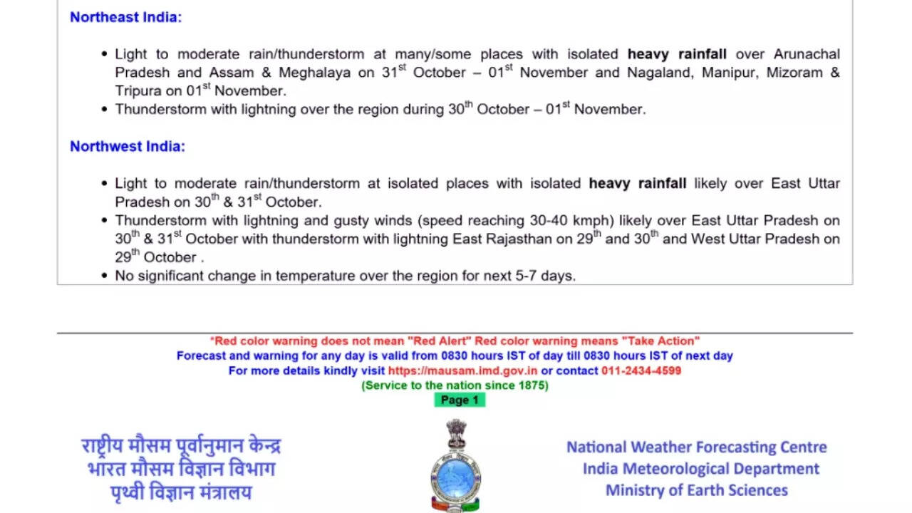
In northeast India, the weather will also take a wetter turn starting October 31. The IMD has forecast light to moderate rain and thunderstorms over Arunachal Pradesh, Assam, and Meghalaya, spreading to Nagaland, Manipur, Mizoram, and Tripura by November 1. The region will likely see isolated heavy rainfall during this period as moist winds from the Bay of Bengal interact with prevailing local systems. The possibility of thunderstorms and lightning are there from October 30 to November. Residents and travellers, especially in the hilly and landslide-prone areas of Arunachal Pradesh and Meghalaya, are advised to stay cautious, and avoid any unnecessary travel. In the northwest, weather conditions are expected to remain relatively mild, though eastern parts of Uttar Pradesh may experience light to moderate rainfall and isolated heavy showers on October 30 and 31. The IMD has predicted thunderstorms with lightning and gusty winds over this region. East Rajasthan may also experience thunderstorms and lightning on October 30, but no significant temperature changes are anticipated across northwestern India for the coming week.Meteorologists attribute this widespread weather activity to the simultaneous presence of two influential systems: the deep depression over south Chhattisgarh, representing the remnants of Cyclone Montha, and the depression over the east central Arabian Sea. The first is gradually weakening as it moves northward, while the second is drifting westward. The IMD’s impact assessment warns of significant disruptions over the next few days. Heavy rain is likely to cause localised flooding, road closures, and waterlogging in the aforementioned affected areas. The department has also highlighted the possibility of landslides and mudslides in hilly terrains.Authorities have urged residents and travelers to exercise caution, advising people to avoid flood-prone routes and unstable structures. Commuters have been asked to check for traffic updates before venturing out, and coastal communities, particularly in Gujarat, Konkan, Karnataka, and Andhra Pradesh, have been strongly advised to stay away from the sea until conditions improve.